
GP 157 Halla Broa XII


mer grejer
0.0
| Plane | Position | Flip |
| Show planes | Show edges |
Parish Find Location Halla
Find Location The Broa (today Broe) cemetery (on a field called ʻBrandenʼ) in Högbro, Halla parish, incorporated into the stone covering of a Viking Age burial.
Find Context Classification Grave
Present Location Classification SHM Storage
Coordinate Present Location (lat) 6581391
Coordinate Present Location (long) 675775
Material Limestone
Height 52
Width 52
Thickness 10
Lindqvist Type B (ca. 500-700)
Lindqvist Shape Dwarf stone
Context and Discovery Lindqvist published 20 picture stones under the name of the farmstead Broa (today Broe), all of which appear to originate from the unusually large Iron Age grave field, which is situated in the south-western part of Halla parish, close to the border to Roma parish, and which had been well known through the ages, firstly mentioned by Strelow in 1633. The farm belongs to the community of Högbro. Since time immemorial, two important country roads, the road Halla-Viklau and the road Roma-Sjonhem (ʻVisbyvägenʼ) intersect here, where a rise consisting of gravel (the ʻhigh bridgeʼ = Högbro) clearly emerges out of the terrain, leading across the great bog system Romamyr-Stormyr. Both roads in turn are intersected by the railway line Roma-Etelhem. The railway intersects both roads a few hundred metres to the west and southwest of the crossing. During the 19th century, the Högbro elevation was severely diminished and large parts of the Broa necropolis were destroyed by clearing and cultivation, gravel mining, house building, railway and road construction, as well as deliberate grave robbing. Many finds from Broa were sold on the antiquities market during this time, with many acquired by ATA. Unfortunately, the large and highly important cemetery of Högbro-Broa is still not published adequately; its present documentation is incomplete and confusing. The best overview about the history and state of research is given by Lena Thunmark-Nylén (1995–2006 III:2, pp. 621–623; IV:1, pp. 324–347).
The first professional and large-scale excavation took place in 1899, conducted by Hans Hansson, who unearthed 14 graves in a small area right next to the intersection, just south of the road Roma-Sjonhem and east of the road to Viklau. One further large-scale excavation was carried out in 1981–82 by Ann-Marie Pettersson, who investigated 120 graves (9 inhumation, 102 cremation, 9 without bones) in a small area (circa 700 m2) about 50 m north of the road Roma-Sjonhem and about 40 m east of the road to Halla (Broe 1:71; see the report compiled by Daniel Langhammer from 2012, RAGU dnr 13/82, 789/84). Apart from that, several minor and poorly documented investigations took place, in the beginning of the 20th century, in particular, during the 1930s and the early 1940s.
Two larger areas are registered by ATA, a burial ground north of the road Roma–Sjonhem (ATA Halla 46:1) and a burial ground south of the road (ATA Halla 48:1). The first one (46:1) covers an area of circa 120 x 110 m (E–W) and contains 66 circular stone settings and 120 investigated flat graves. The other one (48:1) is about 300 x 120 m (N–S) and features 202 circular stone settings. Several other registered monuments, about 15 stone settings, 2 stone kists and 1 gravklot (large spherical stone) seem to belong to the Broa grave field as well (ATA Halla 1:1, 1:2, 74:1, 78:1, 79:1; Roma 31:1, 31:2, 32:1). Thunmark-Nylén (1995–2006 III:2, p. 622) estimates the number of investigated graves alone at about 300 to 400. The actual size and extent of the cemetery, however, remains still uncertain.
The oldest investigated burials can be dated to the Roman Iron Age, and some unexcavated stone settings are typical for the Pre-Roman Iron Age. Most of the graves, however, date to the Migration, Vendel and Viking Periods. First and foremost, the grave field is well-known and frequently cited for some particularly important finds such as the decorated horse harness from the equestrian burial discovered in 1899, after which the Broa Style is named (Salin 1922; Thunmark-Nylén 1992; 1995–2006 IV:1, pp. 325–326), the lyre bridge of amber from the same grave (Reimers 1980), and many remarkable finds of glass vessels from all periods (Nylén 1969). Furthermore, there are several elite warrior graves containing fragments of ring-swords as well as a Vendel helmet (Nerman 1969–1975 I:1, p. 29; II, fig. 601).
The exact location of the find spots of the picture stones is difficult to determine in most cases, and their contexts and relation to the known parts of the cemetery remain unclear. Most of them originate from the railway line and the area west of it (called ʻBrandenʼ) and the rest from the area east of the road to Halla, between the road and the border to Roma (ʻKlosterängenʼ). Lindqvist (1941/42 II, fig. 378) provides a map, which was primarily composed at the National Heritage Board (RAÄ) based on the information kept in ATA. It identifies the location of the find places of the stones as carefully as they could be determined at Lindqvist’s time.
The picture stone fragment Halla Broa XII was found together with two other picture stones in 1915 by Hans Hanson during the examination of the burial mound Broe VI/1915, which was located on the property of the wheelwright Otto Engström (Thunmark-Nylén 1995–2006 IV:1, pp. 330–331). According to the map provided by Lindqvist (1941/42 I, fig. 378), the find spot is situated just west of the intersection between the road to Viklau and the railway line, north of the border to Möllbos gård (farm), in an area called ʻBrandenʼ, where several other picture stones were found. “Under a low earthen mound, a stone setting was discovered that had a diameter of 4.75 m, was free of earth, and consisted of limestone chunks and boulders. In the upper stone layer, without any apparent order, there were three picture stones, two of which ([Halla Broa] XI and XII) lay at the western edge, the third ([Halla Broa] XIII) at the eastern edge. The latter stone was in a slanted standing position. Under this layer of stones, a circle of limestone slabs, with an outer diameter of 3.5 m, was encountered, with a large boulder in its centre. Under this were another layer of smaller stones and finally the skeleton of a man” (Lindqvist 1941/42 II, p. 64). The inhumation grave was undisturbed, with the head of the dead lying in the south. Among the furnishings (SHM 15601:2) were a penannular brooch of bronze, a bronze strap buckle, strap end, and strap joiner, a green glass bead, a knife, and a comb with case (Thunmark-Nylén 1995–2006 IV:1, pp. 330–331; Rundkvist 2012, p. 152–153). The burial can be dated to the 10th century.  GP 156 Halla Broa XI
 GP 163 Halla Broa XIII
Measurements, Material and Condition “Limestone slab, up to 10 cm thick. The obverse even, the narrow sides partially hewn, generally chamfered towards the back. The reverse rough and unworked. Width of the head 52 cm, its height 29 cm, total preserved height of the stone 52 cm, width of the neck 44 cm” (Lindqvist 1941/42 II, p. 64). The fragment represents the complete head of a mushroom-shaped picture stone, including a section of the neck. Only a few very small broken-off parts are visible at the upper edge. The surface is not much weathered. At least when applying oblique light most of the carvings are well discernible.
Description of Ornament and Images Lindqvist (II, figs. 385, 392) provides a drawing by Olof Sörling as well as a photo of the unpainted stone (cf. ATA Run- och bildstenssamling 482:9; 494:6a; 1718:9b). Sörling’s drawing depicts the carvings as described by Lindqvist (ibid. p. 64): “Decorated with thin, carved lines with rounded bottoms. The background field generally is chiselled in the usual fashion, only in the narrow horizontal belt below the ship, it instead is covered crosslines (oars of the sailing ship??) that are at a distance of about 1 cm from each other, but slightly converge towards the top. Within an 8–10 cm wide framing border, which appears to have contained a simplified twisted cord pattern, and above a horizontal bar (border?) at the neck, there is a ship with (at least on the left) a towering stem and a slightly curved keel line as well as a chequered sail with rectilinear framing on three sides, the upper edge of which is convex and runs along the framing border. Above the railing and to the left of the mast, the torso of a crewman (turned to the left??) can be seen. The ship appears to be in an unusually slanting position, but otherwise probably belongs to a common type.” If Lindqvist’s interpretation of the mentioned crosslines as row of oars is correct, Halla Broa XII is the only known picture stone depicting the sail and the oars of a ship at the same time (1941/42 I, p. 73).
Interpretation of the Imagery No interpretation
Type and Dating According to Lindqvist (1941/42 I, pp. 38), the monument represents a Middle-type picture stone, which means a Type B ʻdwarf stoneʼ, dating to between AD 500 and 700. The simple ship, which is placed in the stone’s head field, as on many other Type B monuments, seems to be the only indication considered by him. Lindqvist assigns the vessel to his Rikvidetypus (ibid. p. 66). According to Vareniusʼ (1992, p. 62, appendix 2) typology, the ship belongs to group II (Skepp med enkel rigg), dating to the 7th to 9th century. According to Martin Rundkvist’s (2012, p. 159) typology, the stone’s shape represents Type dwarf3/4. Dwarf 3 belongs to Rundkvist’s period 3, corresponding with the Middle Vendel Period. Dwarf 4, however, occurs in the periods 4–7, which means between the Late Vendel Period and the Late Viking Period (8th to 11th century).
As a matter of fact, the shape of the almost semi-circular head with slightly pronounced corners is typical for late-type (mushroom-shaped) picture stones. The position of the vessel in the head field, however, does not occur on late-type picture stones. Furthermore, the depiction of a ship’s crew does not necessarily indicate a Type C–E stone. A ship with crew can also be seen on the Type B picture stones GP 77 Eskelhem Larsarve I, GP 13 Alva Bopparve, and perhaps GP 166 Halla Broa XVIII. However, the Larsarve stone and in particular Alva Bopparve have much in common with Type C–E stones and therefore have been regarded as late Type B monuments or transitional forms, presumably dating to the 8th century or even later (Oehrl 2019a, pp. 11, 18). See also GP 79 Etelhem järnvägen.  GP 77 Eskelhem Larsarve I
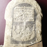 GP 13 Alva Bopparve
 GP 166 Halla Broa XVIII
 GP 79 Etelhem Järnvägslinje
References Lindqvist 1941/42 I, pp. 66, 73; II, p. 64, figs. 385, 392; Rundkvist 2012, p. 152–153 cat. no. 13.
Bildstenen påträffades 1915 som sekundärt använt byggnadsmaterial i en gravhög från 900-talet på gravfältet Broa i Halla socken.
Nuvarande lokalisering
Statens Historiska Museums magasin, Tumba
Beskrivning
Dvärgsten (typ B), 52 x 52 cm, med kantdekorationer och ett bildfält med ett skepp med ett segel och möjligen åror samtidigt. Troligen rester av en besättningsman vid masten.
Datering
Dateringen kan inte anges närmare, men bildstenen tillhör perioden 500-700.
Tolkning
Ingen tolkning.
AA
TitleGP 157 Halla Broa XII
Jan Peder Lamm ID 112
Statens Historiska Museer ID 15601
Lindqvist Title Halla, Broa XII
Last modified Apr 21, 2026

